Live Conditions

Monday, March 25, 2013

A Stubborn Old Man Winter...

It feels like winter just refuses to depart from New Jersey and allow the warm welcome of spring to greet us.  Another winter storm is set to affect us overnight tonight and into tomorrow, giving parts of the state 2-4 inches with the bullseye in South Jersey receiving possibly 4-6.  Untreated surfaces will see accumulation, and will be hazardous.  Treated surfaces will be a bit slick, so exercise caution tomorrow regardless.  A Winter Storm WARNING is in effect for all of South Jersey excluding Cape May County and a Winter Weather Advisory is in place for the rest of the state. 

Here's a timeline for this storm:

Overnight - The storm arrives at the southern part of the state with some light mixed precipitation.

Monday Morning - The morning commute in South Jersey will be a slick one, with rain along the coast, mix further inland, and wet snow in the western half of Southern NJ. Untreated surfaces (any side roads or sidewalks without salt or brine) will be hazardous, so please be cautious when traveling.  Treated surfaces will be wet, but remain mostly snow-free.  There could always be a surprise slippery spot, however, so please be careful while traveling regardless!

Monday Lunchtime - Wet snow will be falling across the entire state, with the heaviest snow in falling in South Jersey.  Again, exercise caution while traveling, regardless if you are on a treated or untreated road or sidewalk. Please remember to turn on headlights when you are driving!

Monday Afternoon/Evening - Snow will become heavier in South Jersey and remain steady Trenton northward. 

Monday Midnight - The storm will begin to depart and the snow will taper off overnight.

Wednesday, March 6, 2013

Updated Snow Map

Here's an updated snowmap for this week's storm.  I upped the snowfall for North Jersey because on Thursday night, all 3 models are showing a "wrap around" chunk of snow falling for that area.  I still feel that South Jersey will mostly be too warm for the bulk of the system, but I removed the rain/mix area because I'm sure they'll see some snow (plus, I felt bad haha). 

MORE IMPORTANTLY, strong winds and costal flooding are the bigger danger from this storm.  Both a High Wind WARNING and a Coastal Flood WARNING are in effect for the entire Jersey coast.  Winds of 20-30mph sustained with gusts up to 60mph are expected along with 6-8ft tides.  Winds and flooding are already impacting the coast and causing a bit of damage.  Voluntary evacuations are in effect for some coastal towns.

  Courtesy NBC 40

Late Night Thoughts on Wednesday Night Storm

I've been tracking the Wednesday night storm for about a week now, but unfortunately, am still a bit unsure as to what I think about it.  The models have been everywhere lately and, quite frankly, I'm not sure what to make of it.  In addition, I'm encountering an interesting feature with this storm that I haven't encountered before.  Some warm air will be wrapping around the center of the Low as the storm matures.  This feature was pointed out to me by one of the meteorology seniors, Dan, who knows quite a bit more about reading models than I do.  This warm air advection would possibly make or break snowfall amounts, especially for areas along the shore.  Additionally, some other factors that take into place are that the surface temperatures the past couple of days have been very mild, the higher sun angle as we approach spring, and the fact that the snow that will be falling will be wet snow.  Regardless, I feel that I ought to issue my snowfall totals map just for practice, thus here it is:
So why am I being such a downer?  Firstly, this storm is just not very strong to begin with, and two of the models, the Euro and GFS, agree with that fact.  Although the NAM is good with close-ranged forecasts, it does tend to over-estimate precipitation values.  Then there's that warm air advection as the storm matures.  How strong will it be?  How much of an impact will it make?  From what I saw of the models, it looked to me as if a good amount of warm air will make its way into the surface.  Although aloft, temperatures will be cold enough, with the warm surface, weak system, high sun angle, and wet snowflakes, I'm seeing snowfall occuring, but the snow having a very hard time sticking.  This map may change as tomorrow's runs come out, but I figure I give my brains a shot at it.  But there you go, there's my two cents...

Monday, February 11, 2013

February 8-9th Nor'easter Summary

Final snow totals:
Northern New Jersey

 Southern New Jersey
Thoughts:  For North Jersey, I believe I got a little too "trigger happy" and drew the borders for the snowfall amounts a little too south.  Had the lines I drew been a little more northern, it would have been a very accurate forecast.  For South Jersey, thought, I feel fairly good about the forecast, with the predictions matching the recorded amounts decently well.

Final Analysis:
24-hour Radar Loop of the Nor'easter

Thoughts:  What an incredible and unique Nor'easter snowstorm!  Firstly, the shear strength behind this storm caused 3-6 inches an hour in parts of Long Island, NY and Connecticut, resulting in one place receiving a foot of snow in 90 minutes and radar signatures for snowfall that were virtually off the charts.  Hamden, CT came in with the highest snowfall in the northeast at 40 inches.

Secondly, this system had two parts to it, both of which merged together more majestically that I've ever seen two system do.

Lastly, the system successfully pulled off a significant "wrap-around" precipitation maneuver, which I have never seen done to such an effect, due to the western end being enhanced by the merged energy of the second half of the system.

You can see these features for yourself in this loop:

0:06 - The two parts of the storm system begin to merge and fill in the gap between them
0:08 - 50+ dBZ radar signature for snowfall, about 3-5 inches an hour (incredibly rare), begin to show up in Long Island, NY and move into Connecticut.
0:10 - The two parts of the system are fully merged and have filled in the entire gap
0:11 - The precipitation and energy from what was the second part of the system are swung southward down eastern NY and into northern NJ, creating a rare enhanced wrap-around effect.

Friday, February 8, 2013

Updated Snow Totals Forecast

So a few things have changed in the forecast, but the main story still exists: lots of snow for the northern counties!  The rain/snow line today was further south than expected, giving some areas a lot of mixed precipitation for the day.  In New Brunswick, about an inch of slush accumulated on the ground, allowing the snow that falls to stick much easier than if it had been rain.  However, the storm itself is slightly weaker, so that mostly balances things out.  This is what I am expecting, but I am feeling that perhaps southern New Jersey will get a bit less than expected, especially since the newer model runs show only a little snow reaching down there overnight tonight. 

Thursday, February 7, 2013

Nor'easter Snowstorm Update

The National Weather Service has now issued a Blizzard WARNING for the northeast tip of the state along with all of New York City, Long Island, all of Connecticut, Rhode Island, and eastern Massachusetts.  Very significant snowfall and strong winds are expected in these areas under the warning and will cause a dangerous situation for anyone outside.  A Winter Storm WARNING was issued for all points north and east of Fort Dix/McGuire Airforce Base.  Heavy snow is expected in those regions accompanied by strong winds, but not strong enough to be categorized as a blizzard.  A Winter Storm Advisory has been issued for South Jersey, where most of the storm will be rain, but will change over to snow for a couple of inches.

As for how much snow, the 18Z runs for the NAM and GFS have come in and it looks like they are in good agreement for an even stronger snowstorm.  The GFS is suggesting a little less snow, but I am going to side with the NAM for this one, since it is the better short-term model.  Below is my personal snow totals forecast, please remember this is not an official one and is only made for practicing purposes:


The heaviest snow will be in Sussex County with up to 18" possible there, gradually decreasing as you move further south.  I attempted to factor in the rain/snow line movement and the enhanced wrap-around snow into the forecast, so we will see how good it ends up.  Below is the official snow forecast from the NWS in Mt. Holly:  

I personally have more confidence in the NWS forecast map than mine, as this is only my second time ever attempting to legitimately forecast snow totals! 

This may be the one!

I know that this past winter has been very disappointing with both the amount of snow and the forecasting of it, however, I feel that this may change very soon (as soon as tomorrow!).  A few days ago, the Euro was showing a very strong Nor'easter impact the state and the region, however, it showed mostly rain initially and the GFS did not agree.  The trend changed though and now the Euro, GFS, and also the NAM are all in agreement that this Nor'easter will dump snow on the region, which is a very good sign for snow lovers.  Additionally, the NWS has put North Jersey under a Winter Storm Watch. The 12Z Euro and NAM are nearly identical and show the possibility of 8-14"+ in North Jersey, 5-8" in Central Jersey, and Southbound, the snow amounts will decrease sharply, and Southern NJ may see only 2-5" with coastal areas seeing even less.  I will be publishing my official snow totals forecast later, but for now here's the timeline:  The storm will begin as rain early Friday morning, increasing in intensity by the early afternoon.  The rain will begin transitioning to snow starting from the northwest and moving southeast during the late afternoon and into the evening.  At this point, winds will be intensifying, with guats reaching 35+mph.  By Friday night, heavy snow will be falling in northeast New Jersey, moderate snow in northwest and Central Jersey, and some light snow in Southern part of the state.  The snow will be tapering off by Saturday morning and the bulk of the storm will leave by noon. 

Again, expect another update from me later today.

Sunday, February 3, 2013

Another Snow Forecast BUST

Sorry folks, that 2-4 inches of snow forecasted didn't make it past a dusting.  For some reason, mother nature this winter likes to give us some hope for snow, but then refuses to deliver.  You could also blame it on the forecaster of course, as this is our job.  At any rate, here's the statewide snowfall map.  Looks like everyone got an inch or less (probably less), far off from what was predicted.  There will be a chance for another snow shower tonight, but don't expect any of it to add anything significant to snow totals.
Statewide, New Jersey received <1 inch of snow during Saturday night's event, less than the forecasted 1-2 and 2-4 inches.

Saturday, February 2, 2013

A Little Snow for the Weekend!

A weak clipper system will be moving through the region this evening and give us a little bit of snow!  The National Weather Service has put parts of the state under a Winter Weather Advisory from Atlantic to Middlesex Counties from 7pm Saturday evening until 1pm Sunday.  The Mt. Holly forecast office is calling for 2-4 inches of snow to fall for parts north and west of central Burlington County.  Localized measurements could reach the 4 inch mark, but most of the area will receive up to 3 inches.  Other parts of the state will get a light 1-2 inches.

This system is less organized than the one that struck South Jersey on Friday morning, so no significant snowfall is expected.  There is a very slight chance that snow amounts could rise as the system will become more organized off shore.  However, current model runs all agree that the system will not organize fast enough to change the forecast.  The snow will make its way into the area around 7-8pm tonight. 
  

Thursday, January 17, 2013

First Snow for South Jersey?

It's been almost two years since South Jersey has seen any accumulating snow, but it looks like we'll be ending our snowless reign tonight! Forecast models are showing a system to the south grazing the southern part of the state delivering up to 6 inches in some parts of the region (see snow forecast below), according to the NWS, who has issued a Winter Storm WATCH for the southern counties.  The folks in Mt. Holly are expressing uncertainty with the forecast, however, as a result of conflicting forecast models, and they should be.  The 00z Euro and GFS models are forecasting snow and are in fair agreement with one another with how much precip would fall and where the storm would be located. The Euro, though, is showing a slower cooling at the surface, which could possibly inhibit snow accumulations a bit. Regardless, the models are still in good agreement with each other. 

Here's where it gets complicated: the NAM, the model acclaimed for its short-term forecasting, is saying no snow, period.  So we're actually finding ourselves in a bit of an awkward spot with the two mid and long range models agreeing while the short range model is becoming the outlier in a short-term forecast.  Going solely on raw forecast data, we unfortunately can't draw any confident conclusions.  Using some logic, though, we can get some answers. 

Firstly, all 3 models agree that temperatures will be cold enough aloft for snow, so we know that it can snow.

Secondly, we've been having some fairly chilly nights, thus we know if any snow falls, it can stick.

Thirdly, a harder question, will it snow?  I personally think yes, it will.  Two out of the three main models are agreeing fairly well that it will snow, and agreement between models is very, very good. 

Lastly, the hardest of all, how much will it snow?  Looking at the models myself, I feel that there is going to be accumulations in South Jersey, but not as much as the NWS is forecasting.  Now granted, the NWS has a team of expert meteorologists who are professionals in the field; I have my wits and my gut, that is all.  But, this is my two cents for what its worth, nonetheless.  I feel that there will be an inch or two less than what is being forecasted by the NWS in all areas, but still accumulations in Southern NJ with more the further south and east you go, but no more than 4 inches throughout (there could always be locally heavy spots).

I'll keep updating as more information and updated model runs come in.  Stay safe!

Tuesday, October 23, 2012

A "Perfect Storm" On Its Way?

Below is the Oct 23rd 00Z model output for the European Forecast Model:
For the past week, the Euro has been consistently showing a powerful hurricane striking the Northeast during the week of Halloween, around the 30th.  This, of course, brings back memories of Irene last year in August.  However, this storm, now deemed "Sandy", is very unique according to the Euro.  Most east coast hurricanes take one of two paths: one that veers it eastward into the Atlantic; another that grazes the shoreline, similar to Irene.  Sandy, however, looks like it may take an interesting path that is almost inconceivable - a sharp turn westward, straight into the Northeast:
To be honest, this is a very, very unusual, almost improbable path for a hurricane to take, however, the Euro is showing an extremely strong trough developing over the Continental US that essentially creates a pocket for Sandy to potentially get pulled westward.  On a normal basis, I would consider such a forecast to be a "goof" of the forecast model, however, the consistency of the Euro for the past week is worrisome and a cause for alarm.  In addition, meteorologists across the country are very aware of the building situation and are shocked and concerned.  If this track holds true, which I feel is likely, the Northeast could be the epicenter of an unprecedented weather catastrophe. 


Monday, August 6, 2012

Another East Coast Hurricane?

Around this time last year, the Extended GFS Forecast Model showed Irene making a direct impact to the Eastern Seaboard two weeks ahead of it's landfall.  Now today's 12Z GFS Model is having a deja vu moment and showing yet another hurricane for the East Coast in about two weeks or from the remnants of Florence.  Now as a disclaimer, it is way too far out to even surely say a hurricane will form at all, let alone take this exact route.  The GFS Model is known to issue inaccurate forecasts, especially two weeks ahead of time.  Instead, the GFS tends to give a general forecast, as per my nickname for it, the "General Forecasting System" (real name is Global Forecasting System).  However, in the defense of the GFS, it did forecast Irene quite well last year, providing an accurate and decently precise track two weeks ahead of time.  In addition, it is one of the better hurricane forecast models out there along with the GFDL and European Models, but note that better does not necessarily mean great.  Unfortunately I cannot give a sure say to where, when, or even if a hurricane will hit the Eastern US as much as I would like to, but I will say that we need to keep an eye out for the middle of the week around the 22nd. 

Friday, August 3, 2012

Tropical Storm Ernesto Forms

Yesterday afternoon, the National Hurricane Center officially named the tropical system in the Caribbean Tropical Storm Ernesto.  Currently, Ernesto stands just north of Venezuela with maximum sustained winds of 50 mph moving west at 21 mph.  The track currently takes Ernesto on a northwesterly track towards the Gulf of Mexico.  Different models have Ernesto making landfall in different areas, from Cancun, Mexico to Western Cuba.  From there, some models take it into the Florida Panhandle while others take it towards Texas.  The NHC has Ernesto becoming a hurricane by Monday morning around Jamaica.  Keep track of Ernesto by checking out WeatherCoat's TropiCoat or by going to hurricanes.gov.

Wednesday, July 4, 2012

Hit by a "Derecho"


South Jersey knows the name of a new storm: derecho.  For those of you who are unfamiliar with it, "a 'derecho' is a long-lived, rapidly moving line of intense thunderstorms that produces widespread damaging winds in a nearly continuous swath (NOAA).  These winds are intense straight-line winds that reach over 58mph, often approaching 100mph.  This intense line of thunderstorms must travel a minimum of 240 miles in order to be considered a derecho.  
On Saturday June 30th, 2012, at approximately 1:00am, a Severe Thunderstorm Warning was issued for all of southern New Jersey.  Upon receiving the message, I went to check the radar and was astonished by what I saw.  The radar signature showed a large bow echo-I immediately knew the imminent threat of this storm.  The storm cell quickly approached the region and knocked out power shortly after the warnings were issued.  All you could hear was the howling wind outside.  The storm worsened quickly, with wind gusts rapidly accelerating up to over 80mph.  I personally wanted to step outside for a moment to see the wrath of the storm, but I was honestly terrified of the storm.  As someone who enjoys experiencing the wrath of nature, even this was too much.  The derecho swept through South Jersey, delivering it's unforgiving winds, causing widespread damage.  Within an hour, the worst of the storm was over, and everything was dark.

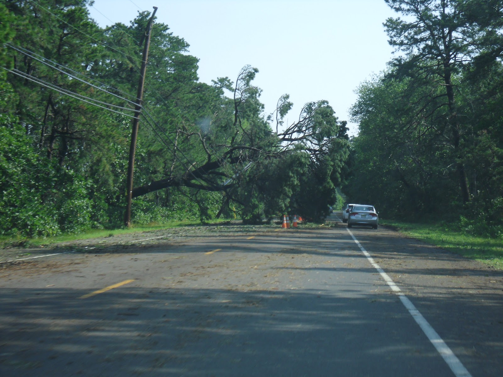
When morning broke, everyone was unaware as to the damage that had occurred from the storm.  As I drove down the street and turned out of my development, Rutgers bound for a club meeting, I was struck with this scene just a few hundred feet away:
As I continued on, the damage became more apparent, and I was rendered speechless.  Downed trees and wires were everywhere, no street intersections had power, and all Wawa's and gas stations around South Jersey were closed.  South Jersey was crippled.

Atlantic, Cape, Cumberland, and Salem counties are struggling to recover from this monster storm.  Utility crews from around the nation came over and helped our recovery efforts and we were grateful for their service.  Its being reported that it could take over a week to restore power to all customers; my family struck lucky and received it back in 4 days.  For the most part, people remained calm through the chaos, helping one another and being patient.

As for the derecho itself, the storm began in the Mid-West, around Illinois and traveled it's way into the Mid-Atlantic, wreaking havoc throughout the Central Atlantic.  Wind gusts were measured up to 87mph in Atlantic City International Airport.  The system lasted approximately 18 hours and traveled 800miles from the Mid-Atlantic, through the Central Atlantic, into the Atlantic Ocean.  The damage was widespread and massive.  In total, 22 people lost their lives in the storm. 


Thursday, May 17, 2012

Forecasts are back! Sunny for the weekend, rainy start to the week?

WeatherCoats is happy to bring back its Extended Forecast for the summer!  For the weekend, we're looking at some nice conditions overall with sunshine and comfortable temperatures.  For Monday, we're watching a coastal storm as forecast models are still in a slight disagreement.  The NAM and EMCWF (European) forecast models are suggesting that there will be some decent rain from the storm on Monday while the GFS only suggests some light rain.  So in the forecast I'm putting mostly clouds with a chance of a good shower for Monday.  As for Tuesday, all the models are in agreement that a weak cold front will push through and give us a little wet weather for the day with a few lingering showers for Wednesday.  Conditions look to be clearing out by Thursday for a nice, warm day.

Looking ahead:  Memorial day weekend looks to be mostly dry, but there could be a few showers...

Thursday, April 5, 2012

My April Fools Day Forecast!

 
So for the first time ever, someone recognized me from doing the weather forecasts for WeatherWatcher!  To be honest, I was a bit taken back and at first felt a bit... awkward, but afterwards I felt flattered that someone recognized me, and even knew my name!  My April Fools Day 2012 forecast must've stuck with them (not in the same way my April Fools Day 2011 blooper reel sticks to people hahaha). 

Saturday, March 24, 2012

A Cooler Forecast for the Week

A cooler day today with cloudy skies and rain later on tonight and into tomorrow. Sunny skies come back for the week, but the cooler temperatures linger.