Live Conditions

Tuesday, October 23, 2012

A "Perfect Storm" On Its Way?

Below is the Oct 23rd 00Z model output for the European Forecast Model:
For the past week, the Euro has been consistently showing a powerful hurricane striking the Northeast during the week of Halloween, around the 30th.  This, of course, brings back memories of Irene last year in August.  However, this storm, now deemed "Sandy", is very unique according to the Euro.  Most east coast hurricanes take one of two paths: one that veers it eastward into the Atlantic; another that grazes the shoreline, similar to Irene.  Sandy, however, looks like it may take an interesting path that is almost inconceivable - a sharp turn westward, straight into the Northeast:
To be honest, this is a very, very unusual, almost improbable path for a hurricane to take, however, the Euro is showing an extremely strong trough developing over the Continental US that essentially creates a pocket for Sandy to potentially get pulled westward.  On a normal basis, I would consider such a forecast to be a "goof" of the forecast model, however, the consistency of the Euro for the past week is worrisome and a cause for alarm.  In addition, meteorologists across the country are very aware of the building situation and are shocked and concerned.  If this track holds true, which I feel is likely, the Northeast could be the epicenter of an unprecedented weather catastrophe. 


Monday, August 6, 2012

Another East Coast Hurricane?

Around this time last year, the Extended GFS Forecast Model showed Irene making a direct impact to the Eastern Seaboard two weeks ahead of it's landfall.  Now today's 12Z GFS Model is having a deja vu moment and showing yet another hurricane for the East Coast in about two weeks or from the remnants of Florence.  Now as a disclaimer, it is way too far out to even surely say a hurricane will form at all, let alone take this exact route.  The GFS Model is known to issue inaccurate forecasts, especially two weeks ahead of time.  Instead, the GFS tends to give a general forecast, as per my nickname for it, the "General Forecasting System" (real name is Global Forecasting System).  However, in the defense of the GFS, it did forecast Irene quite well last year, providing an accurate and decently precise track two weeks ahead of time.  In addition, it is one of the better hurricane forecast models out there along with the GFDL and European Models, but note that better does not necessarily mean great.  Unfortunately I cannot give a sure say to where, when, or even if a hurricane will hit the Eastern US as much as I would like to, but I will say that we need to keep an eye out for the middle of the week around the 22nd. 

Friday, August 3, 2012

Tropical Storm Ernesto Forms

Yesterday afternoon, the National Hurricane Center officially named the tropical system in the Caribbean Tropical Storm Ernesto.  Currently, Ernesto stands just north of Venezuela with maximum sustained winds of 50 mph moving west at 21 mph.  The track currently takes Ernesto on a northwesterly track towards the Gulf of Mexico.  Different models have Ernesto making landfall in different areas, from Cancun, Mexico to Western Cuba.  From there, some models take it into the Florida Panhandle while others take it towards Texas.  The NHC has Ernesto becoming a hurricane by Monday morning around Jamaica.  Keep track of Ernesto by checking out WeatherCoat's TropiCoat or by going to hurricanes.gov.

Wednesday, July 4, 2012

Hit by a "Derecho"


South Jersey knows the name of a new storm: derecho.  For those of you who are unfamiliar with it, "a 'derecho' is a long-lived, rapidly moving line of intense thunderstorms that produces widespread damaging winds in a nearly continuous swath (NOAA).  These winds are intense straight-line winds that reach over 58mph, often approaching 100mph.  This intense line of thunderstorms must travel a minimum of 240 miles in order to be considered a derecho.  
On Saturday June 30th, 2012, at approximately 1:00am, a Severe Thunderstorm Warning was issued for all of southern New Jersey.  Upon receiving the message, I went to check the radar and was astonished by what I saw.  The radar signature showed a large bow echo-I immediately knew the imminent threat of this storm.  The storm cell quickly approached the region and knocked out power shortly after the warnings were issued.  All you could hear was the howling wind outside.  The storm worsened quickly, with wind gusts rapidly accelerating up to over 80mph.  I personally wanted to step outside for a moment to see the wrath of the storm, but I was honestly terrified of the storm.  As someone who enjoys experiencing the wrath of nature, even this was too much.  The derecho swept through South Jersey, delivering it's unforgiving winds, causing widespread damage.  Within an hour, the worst of the storm was over, and everything was dark.

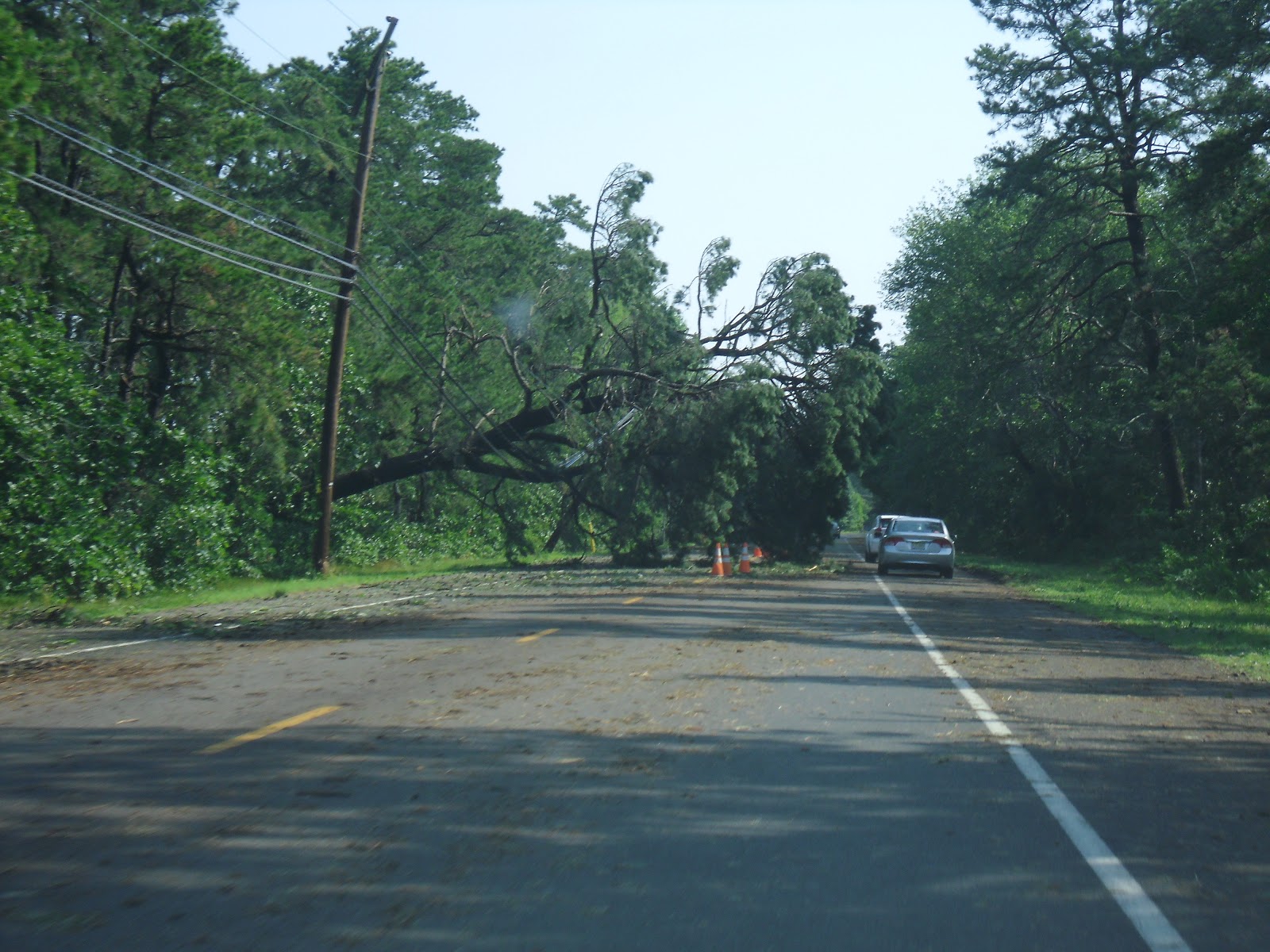
When morning broke, everyone was unaware as to the damage that had occurred from the storm.  As I drove down the street and turned out of my development, Rutgers bound for a club meeting, I was struck with this scene just a few hundred feet away:
As I continued on, the damage became more apparent, and I was rendered speechless.  Downed trees and wires were everywhere, no street intersections had power, and all Wawa's and gas stations around South Jersey were closed.  South Jersey was crippled.

Atlantic, Cape, Cumberland, and Salem counties are struggling to recover from this monster storm.  Utility crews from around the nation came over and helped our recovery efforts and we were grateful for their service.  Its being reported that it could take over a week to restore power to all customers; my family struck lucky and received it back in 4 days.  For the most part, people remained calm through the chaos, helping one another and being patient.

As for the derecho itself, the storm began in the Mid-West, around Illinois and traveled it's way into the Mid-Atlantic, wreaking havoc throughout the Central Atlantic.  Wind gusts were measured up to 87mph in Atlantic City International Airport.  The system lasted approximately 18 hours and traveled 800miles from the Mid-Atlantic, through the Central Atlantic, into the Atlantic Ocean.  The damage was widespread and massive.  In total, 22 people lost their lives in the storm. 


Thursday, May 17, 2012

Forecasts are back! Sunny for the weekend, rainy start to the week?

WeatherCoats is happy to bring back its Extended Forecast for the summer!  For the weekend, we're looking at some nice conditions overall with sunshine and comfortable temperatures.  For Monday, we're watching a coastal storm as forecast models are still in a slight disagreement.  The NAM and EMCWF (European) forecast models are suggesting that there will be some decent rain from the storm on Monday while the GFS only suggests some light rain.  So in the forecast I'm putting mostly clouds with a chance of a good shower for Monday.  As for Tuesday, all the models are in agreement that a weak cold front will push through and give us a little wet weather for the day with a few lingering showers for Wednesday.  Conditions look to be clearing out by Thursday for a nice, warm day.

Looking ahead:  Memorial day weekend looks to be mostly dry, but there could be a few showers...

Thursday, April 5, 2012

My April Fools Day Forecast!

 
So for the first time ever, someone recognized me from doing the weather forecasts for WeatherWatcher!  To be honest, I was a bit taken back and at first felt a bit... awkward, but afterwards I felt flattered that someone recognized me, and even knew my name!  My April Fools Day 2012 forecast must've stuck with them (not in the same way my April Fools Day 2011 blooper reel sticks to people hahaha). 

Saturday, March 24, 2012

A Cooler Forecast for the Week

A cooler day today with cloudy skies and rain later on tonight and into tomorrow. Sunny skies come back for the week, but the cooler temperatures linger.

Thursday, February 2, 2012

New Web Design AND 6 More Weeks of Winter

WeatherCoats is proud to announce it's new web design with a cleaner-cut look with the same easy navigation as before!

In other news, Punxsutawney Phil, the famous Pennsylvanian groundhog, woke up this morning from his lair and saw his shadow!  You know what that means:  6 more weeks of winter!  Now, this past winter has been consistently above average in temperatures, so I wonder if Phil is saying that we'll have 6 more weeks of nice weather, or that winter has yes to come!  Either way, Phil has only been right about 39% of the time, so stick with WeatherCoats! ;D

Friday, January 20, 2012

RU WeatherWatcher - Snow on its way!

 
The forecast has changed!  Most of NJ is now under a Winter Weather Advisory on Saturday from 1am-5pm.  Expect 2-5 inches of snow for New Brunswick and 1/10th of an inch of ice tomorrow.  Go to WinterCoat to get the latest snow totals forecast for all of NJ.  Stay safe everyone!

Wednesday, January 18, 2012

A Little Snow This Week

The forecast for this week shows a chance for a little bit of snow for Thursday Night and from Friday night into Saturday night.  No significant accumulation is expected, but with a winter that has had less snow than fall in half the state, any amount of snow is something to talk about.  Regardless, always exercise caution while driving when it's snowing!